Geospatial mapping coverage overlays
 High level project overview
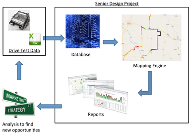
For my senior design project, my group is working with John Deere to develop a geospatial mapping coverage overlays web application for test data collected at John Deere. This tool will allow John Deere to upload drive test data from their GPS receiver into the web application. The web application will process the data and store it into a database for long-term storage. The web application will also have a graphical user interface that displays a map view and plots the corresponding points from the database onto the map displaying different attributes of information, light signal strength and data transfer bandwidth.
This tool will help John Deere by allowing them to analyze different aspects of their test data to find areas to improve their product or fix issues that they are experiencing. My role in this group is the Team Leader and I am responsible for contacting any outside contacts and keeping in close contact with our faculty advisors along with our client, John Deere. An important skill I have learned so far in the beginning stages of the project is that keeping in touch with the client can get complicated when trying to schedule a meeting when they have other projects they are working on as well as myself focusing on other courses during the semester.
One solution that I believe our project will assist in is feeding the world. John Deere's goal is to feed the 7 billion people that will be living on the Earth in the year 2050. In order to do this, their agriculture equipment must be improved by innovating new ways to achieve better yields. One aspect of this is accurately driving a tractor or combine through the field. The more accurate this is, typically the higher the yield that is produced from that field.
A second solution from this project is to help improve the accuracy of the testing they perform on the units as well as encourage more customer's to use their product. If John Deere can recommend a particular feature to a grower that works well where their fields are located, then that grower will be able to produce better yields for their money and will in turn produce more food for the global area.
Our team website is located at this URL: http://may1610.sd.ece.iastate.edu
